IN SEARCH OF NOAH’S ARK: Wyatt’s quest: Part 1, LIFE magazine
 EDITORS’ NOTE: For almost 40 years — until his death in 1999 — Ron Wyatt of Madison, Tenn., did more than almost anyone to popularize interest in the search for Noah’s Ark.
Over more than 20 years, Wyatt made repeated trips to a site in eastern Turkey that he passionately believed held the Ark’s remains. Trained in medicine — not archeology or geology — Wyatt continued to gather evidence, despite financial and governmental restrictions, and doggedly pursued a full scientific investigation of the site. Some disagree with his conclusions, but his measurements, soil samples, metal detector readings and radar scans should not simply be dismissed.
After all, he was not alone in thinking that his findings showed an ancient shipwreck hundreds of miles from the nearest sea, in the precise mountain range where the Bible says the Ark came to rest.
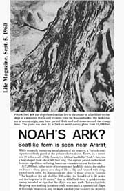
 NASHVILLE, Tenn. (BP)–Ron Wyatt opened his Sept. 5, 1960 issue of LIFE magazine, and his heart leaped at what he read:
“While routinely examining aerial photos of his country, a Turkish army captain suddenly gaped at the picture shown above. There, on a mountain 20 miles south of Mt. Ararat, the biblical landfall of Noah’s Ark, was a boat-shaped form about 500 feet long. The captain passed on the word. Soon an expedition including American scientists set out for the site.
“At 7,000 feet, in the midst of crevasses and landslide debris, the explorers found a clear, grassy area shaped like a ship and rimmed with steep, packed-earth sides. Its dimensions are close to those given in Genesis: ‘The length of the ark shall be 300 cubits, the breadth of it 50 cubits, and the height of it 30 cubits,’ that is, 450x75x45 feet. A quick two-day survey revealed no sign that the object was man made. Yet a scientist in the group says nothing in nature could create such a symmetrical shape. A thorough excavation may be made another year to solve the mystery.”
Below an intriguing photo ran the caption: “From the air, the ship-shaped outline lies in the center of a landslide that is only 25 miles from the Russian border. The landslides are of recent origin, may have packed thick mud and stones around the strange form. The photo was shot by a Turkish aerial survey plane from 10,000 feet.”
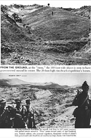
Captions under two other photos explained that a ground expedition explored the 160-foot-wide, grass-covered mound that sharply contrasted with the rugged terrain around it. A rim 20 feet high traced a ship-shaped outline around the smooth, oval knoll.
Since 1949, Ark expeditions had been conducted on Mt. Ararat at 15,500 feet, where aerial photographs revealed a remarkable boat-shaped “anomaly.” But this new discovery was at 7,000 feet, in a location far more accessible to explorers.
Wyatt, then 27, knew he had to find a way to see the site for himself.
Unfortunately, family matters and financial limitations made that extremely unlikely, so Wyatt had to content himself with research in libraries and bookstores — and he found very little serious study had been focused on the subject. Because Ararat is a volcanic mountain, he studied volcanoes. He built little peaks in a stream and floated a scale model of the Ark toward them, to see how the Ark might have reacted to different shapes of mountains rising from the floodwaters. He concluded that the vessel never would have come to rest high on the mountain but would have settled into a crescent-shaped plateau, like the one at 7,000 feet where LIFE’s “boat-shaped form” was located.
NEXT: Tantalizing evidence in Turkey, 1977
Based on accounts of Ron Wyatt’s expeditions archived by Wyatt Archeological Research at wyattmuseum.com.
Originally published at https://www.bpnews.net/bpnews.asp?ID=209354


